 |
|
|
|
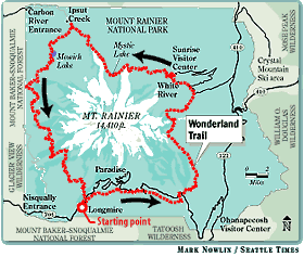
Mount Rainier's Wonderland Trail
Built in 1915, the famous 95-mile footpath occupies a route where engineers in the 1930s envisioned a paved "Wonderland Highway" to circle the mountain. The trail constantly traverses Mount Rainier's dozens of lava-formed ridgelines, resulting in few level portions along the route. A hiker who completes the trail will have amassed a cumulative elevation gain of more than 20,000 feet, nearly 6,000 feet higher than the mountain. Writer/adventurer Terry Wood hiked the Wonderland Trail for The Seattle Times last summer. Here are his stories, photos and recommendations for other hikers interested in this unique Northwest experience.
|
|
|
|
|
||||||||||||||||||||||||
|
[ seattletimes.com home ]
[ Classified Ads | NWsource.com | Contact Us | Search Archive ] Copyright © 2001 The Seattle Times Company
|